Vashon Landslides

With our extensive waterfront exposure, Vashon is prone to serious landslides. Whether initiated by severe storms which increase water pressure in the soil - effectively lubricating ground structures, by earthquakes, by undermining seawater and tidal action, or landowner modifications, landslides have been a regular part of the island's geologic history and will continue to be.

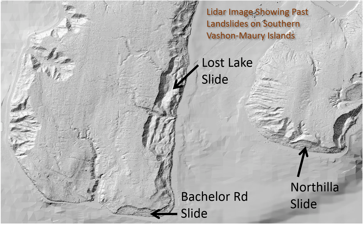
We have multiple communities located in slide risk zones, many of which rely on a single road for access - which also may be susceptible to slides. Rescuers may have to come in via boats from elsewhere in the region. Over 1000 of Vashon homes are waterfront properties. With 54 miles of shoreline, we have the longest coastline in King County - much of it with an elevated risk of landslides.

Our severe fall storms can easily add huge amounts of water to slopes, with a resulting increase of slides for weeks and months afterwards.

The Nisqually earthquake in February 2001 caused various local landslides, including one that nearly affected I-5 between the King County Airport and the Interstate-90 interchange.

The big culprit? "Human activity is responsible for causing about 80% of historical Seattle landslides," - William H. Schulz's 2006 study of local landslides

Although landslides can and do occur in almost any part of the state, King County and the Puget Sound Basin are especially vulnerable due to our urban environment and unique geological conditions. Because of our high population density and the fact that many structures are built either on top of or below bluffs and slopes subject to landslides, more lives are endangered during these land movements and there is a greater potential for damage or destruction to private and public property. Many of the major valleys and shoreline bluffs of Puget Sound are bordered by steeply sloping unconsolidated glacial deposits that are highly susceptible to landslides. Allowing for the possibility of a landslide occurring in our area is an essential component to your family emergency plan.

Landslide Types

The four basic types of landslides are displayed here - from the WA Department of Ecology's site. Click on each for DOE's  explanation.

Deep Seated Landslide Diagram Shallow Landslide Diagram Bench Landslide Diagram Large Landslide Diagram

Recognize Landslide Warning Signs

  • Changes occur in your landscape such as patterns of storm-water drainage on slopes (especially the places where runoff water converges) land movement, small slides, flows, or progressively leaning trees.
  • Doors or windows stick or jam for the first time.
  • New cracks appear in plaster, tile, brick, or foundations.
  • Outside walls, walks, or stairs begin pulling away from the building.
  • Slowly developing, widening cracks appear on the ground or on paved areas such as streets or driveways.
  • Underground utility lines break.
  • Bulging ground appears at the base of a slope.
  • Water breaks through the ground surface in new locations.
  • Fences, retaining walls, utility poles, or trees tilt or move.
  • A faint rumbling sound that increases in volume is noticeable as the landslide nears.
  • The ground slopes downward in one direction and may begin shifting in that direction under your feet.
  • Unusual sounds, such as trees cracking or boulders knocking together, might indicate moving debris.
  • Collapsed pavement, mud, fallen rocks, and other indications of possible debris flow can be seen when driving (embankments along roadsides are particularly susceptible to landslides).

- From www.ready.gov/landslides-debris-flow

Signs of Landslide Activity

WA DNR's Signs of Landslide Activity

- Source: WA Dept. of Natural Resources

Understanding Vashon's Geology

Typical Vashon Geology

The King County Department of Natural Resources and Parks worked with the Vashon Liquid Assets effort to create a neat geologic map of Vashon. Click on it for a full resolution PDF version of it. Also see their Water Resources page for more analytic resources.

Protecting Our Properties

Fortunately there are a number of effective mitigation steps landowners and neighborhoods can take to minimize landslide risks - to protect your families, pet, livestock and lands.Only an expert can properly analyze your specific situation.

  • Do your homework before you buy
  • Don't alter slopes by cutting trees to open a view, by putting waste piles on them, excavating toes of slopes, or anything else without expert guidance.
  • Get mitigation advice if living in a slide-risk area:
    • Consult geotechnical experts about drainage
    • PLANT!  (Or at least don’t log!)
    • Avoid water features (e.g., Koi ponds)
    • Avoid bulkheads/retaining walls
  • Static groundwater pressure (Piezometer) evaluation
  • Slide-risk neighborhoods:
    • Stop ignoring the elephant in the room. Talk about it!
    • Evaluation by hazards geologist
    • Neighbors share mitigation cost/work
    • Talk about alternate escape/evac routes
    • Make/keep kits in EVERYONE’S home
    • Watch for signs of current movement/oozing – don’t ignore it!
  • Make a plan:
  • Participate in drills

King County Landslide Risk Maps

Vashon portion of King County Landslide Hazard Map from 2010. Click map for full resolution PDF version.

2010 Vashon Landslide Risk Map.jpg


King County Landslide Hazard Areas: Sensitive Areas Ordinance Designations' map

Click on link or map below to view full map and details of color designations. (screenshot Nov 2023)


Cumulative Precipitation and Intensity of Precipitation appear to the best predictors of landslide potential over time. See  https://www.usgs.gov/programs/landslide-hazards/science/seattle-area-washington for more on the theory and studies on these values locally.

Cumulative Precipitation Threshold Intensity-Duration Threshold
soap2day