Vashon's Tsunami Risks

Most folks correctly presume that the Straits of Juan de Fuca would protect Vashon from the worst effects of a cross-Pacific, or Cascadia Earthquake induced tsunami. However, we still are likely to see some serious impacts from that (especially in Quartermaster Harbor) – but more likely from local sources of tsunamis and seiches within Puget Sound.

YouTube Video showing 1-3 meter inundation from a Cascadia event: https://www.youtube.com/watch?v=YhjsAjZQZeg & a closer view the inner Puget Sound showing up to a ~3+ meter impact to Quartermaster Harbor - some THREE hours after the initial quake! More recent videos are up at: https://www.dnr.wa.gov/programs-and-services/geology/geologic-hazards/tsunamis

Though not fully studied, there are a number of well researched reports that indicate the scale of what we might face.

http://www.pmel.noaa.gov/pubs/PDF/vent2981/vent2981.pdf (~8 MB)

has some Vashon specific information – which is presented here – even though taken out of context:

Seattle Fault Scenario

The southern wave front splits into two upon striking the northern tip of Vashon Island 4 min after initial deformation. The eastern and more intense front travels down East Passage striking northern Maury Island and Dumas Bay and then reflecting off the Ruston Way waterfront and southern Vashon Island 12 min after generation (Fig. 7). The weaker west front travels down Colvos Passage striking Point Defiance before joining with the stronger reflected wave in Dalco Pass. Maximum wave crests of approximately 3.5 m amplitudes reach Commencement Bay and Gig Harbor approximately 19 min after generation (Fig. 6). Part of the primary front’s reflected wave energy travels north into Quartermaster Harbor and back up East Passage toward Elliott Bay and northern Puget Sound. The remaining wave energy travels into The Narrows and then dissipates in southern Puget Sound. Smaller though still significant waves continue to reflect back and forth within the study region for 3 hr.

High (>1.5 m/s) wave velocities occur within Commencement Bay, Gig Harbor, East Passage, Quartermaster Harbor, The Narrows, and Wollochet Bay. Since the model does not dynamically include tidal currents, the current speeds may be more substantial if these events occurred during a flood tide.

- Pg 10

Tacoma Fault Scenario

Inundation occurs at both State ferry terminals approximately 18 min after tsunami generation. The Tahlequah terminal at the southern point of Vashon Island is hit with an initial 3.3-m wave with speeds ranging from 5–7 m/s and overtopping the dock and staging area. A 3.9-m wave strikes the Point Defiance terminal and marina at speeds of approximately 3 m/s

- Pg 12

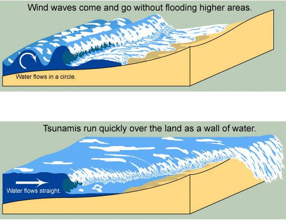
Background Tsunami Information

NOTE: Also see this blog post for Vashon-specific tsunami information that has yet to be reflected on this page.

WA State Tsunami 101 Brochure

Tsunami Warnings?

DNR Jan 2021 Inundation & Current Speed Maps

In January, the Washington Geological Survey (WGS) published a new set of maps derived from their “inundation models […] based on the shape of the ocean floor, the topography of the land, and the expected size and shape of tsunami waves. These properties are derived from what we know about past earthquakes and tsunamis that are found in the geologic record of the Pacific Northwest. The result of the modeling is a series of maps that show the expected depth of water and the speed of the currents from an earthquake-generated tsunami.”

Click here to download DNR’s new tsunami hazard maps of the Puget Sound and adjacent waters (Map Series 2021-01). The last file in the zip includes the report.

Note that this is a large (70MB) file and may take some time to download.

New tsunami modeling using a large earthquake scenario along the Cascadia subduction zone is now available for all areas within the Puget Sound and parts of the Strait of Georgia, some of which had not been modeled before.

This modeling uses a simulated magnitude 9.0 earthquake that produces a tsunami that is unlikely to be exceeded in the next great earthquake. The intent of the modeling is to encourage hazard planning and increase community resilience. The earthquake scenario presented here is based on one that was recently used to estimate the hazard posed to Oregon by tsunamis. However, because tsunamis generated offshore must enter through the Strait of Juan de Fuca to reach Washington’s inner coastline, our scenario adopts a fault geometry that extends farther north than the one used for Oregon. This extension better represents a tsunami generated offshore of northern Washington.

The updated subduction zone geometry assumes a full-length rupture that spans ~775 mi from northern California to the northern end of Vancouver Island, Canada. Scientists inferred that this scenario encompasses ~95 percent of the variability of Cascadia tsunami simulations. Modeling results indicate that the tsunami would first arrive in all inner coastal waterway locations as a trough, with sea level gradually receding.

The first tsunami wave generated by the earthquake would arrive on the west side of Whidbey Island approximately 1 hour and 30 minutes after the earthquake, with large wave crests in excess of 16 ft (5 m) traveling north into the Strait of Georgia and south through Puget Sound.

Most other locations within Puget Sound and parts of the Strait of Georgia would encounter this first tsunami wave within 2–4 hours of the earthquake, leaving little time to issue official warnings, although any felt earthquake shaking is an immediate warning. Fast moving currents from the tsunami waves could locally exceed 9 knots in multiple harbors, inlets, and passages within the narrow waterways of Washington’s inner coastline, presenting a significant navigational hazard to the maritime community.

Tsunami wave inundation would likely continue over 14 hours and remain hazardous to maritime operations for more than 24 hours. This study is limited in that modeling does not account for tide stage, tidal currents, earthquake-induced landslides, seiches, liquefaction, or minor topographic changes that would locally modify the effects of tsunami waves. In addition, there are many assumptions associated with the scenario earthquake and its probability of occurrence modeled here. Due to these limitations, this modeling is unsuitable for site-specific tsunami inundation assessment or for determining effects on the built environment. Instead, we recommend using this modeling as a tool to assist with emergency preparations and evacuation planning prior to a Cascadia subduction zone event.”

– Abstract from Tsunami Hazard Maps of the Puget Sound and Adjacent Waters—Model Results from an extended L1 Mw 9.0 Cascadia Subduction Zone Megathrust Earthquake Scenario  ger_ms2021-01_tsunami_hazard_puget_sound_pamphlet.pdf

A little more dramatic is their 2019 tsunami videos, available on DNR’s YouTube channel at: https://bit.ly/2UakcB8

More tsunami information is at: https://www.dnr.wa.gov/tsunami

soap2day